
Victorian High Country - 30th September to 3rd October 2003
Tuesday 30th September
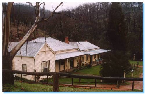
We headed off early morning to North East Victoria for a complete contrast in scenery and climate to last weeks trip. Our first destination was Bright and we arrived around lunchtime. We had some time to kill before our check in at the Odd Frog so we relaxed on the banks of the Ovens River and spent some time looking in the small assortment of shops in the town centre. I bought myself a decent pair of walking shoes and we sat and enjoyed a cappuccino. Check in time soon came around so we drove up to the Odd Frog and made ourselves at home. The apartment was very nice, being all architecturally designed with corrugated iron, tiles and timber. Studios 2 and 3 would be the pick of the 3, being higher up the hill to take advantage of the great valley views over Bright.
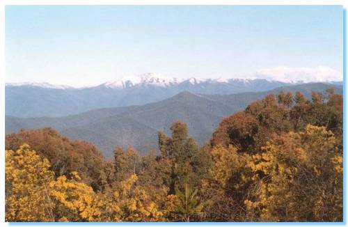
We then went for a drive around Bright, where we made our way up to Clearspot lookout. The lookout was perfectly named, having panoramic views from Hotham across Bogong and to Buffalo and beyond. Seeing the snow capped peaks was magical without a sound to be heard apart from the Currawongs which seemed to be ubiquitous in Bright.
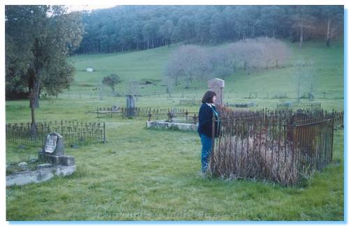
From Clearspot we descended down a 4WD track and made our way along various forestry tracks to the Buckland Valley. We visited the Buckland Cemetery, and continued on into the forest through the valley to a bushcamp, where we tried a little fishing. The river was flowing quite fast from the snow melt, and I couldn't find any deep calmer spots so the fishing was not a success. With darkness falling we packed up and headed back to grab a Pizza for dinner which we enjoyed around a warm log fire.
Wednesday 1st October
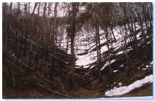
Late morning we drove into Harrietville where we fitted the car out with chains. The weather was fine with no likelihood of them being required but Vic Roads had extended the season an extra week so $27 was small insurance to avoid the fine. From Harrietville we were soon ascending the steep Alpine Road, and I was able to see how much the trees had started to recover since my trip here 6 months ago.
The trees were all sprouting leaves from their branches and trunks, and though the trunks still showed where they had been scorched and the ground was quite black, there was a reassuring amount of green returning to the bush.
We continued on past Hotham where some late season people were still doing some skiing. This was my first time to Hotham when there was snow here! We looked around Dinner Plain with a light snow falling and made our way along the winding Alpine Road through Slippery Pinch and into the Victoria Falls Historic Area.
We spent a little time here near the campsite where I tried some more
unsuccessful fishing. We headed off down the road that used to be the
aqueduct which served Victorias first Hydroelectric scheme. The road took
us past the deep gorge of the Cobungra River where we could see the falls
clearly from the road. The road ended at a header pond where the water
then plummeted down pipes to the station, which supplied power for the Cassilis
Mine. We didn't make the walk down the track, so we don't know if any
remains survived the January Fires.
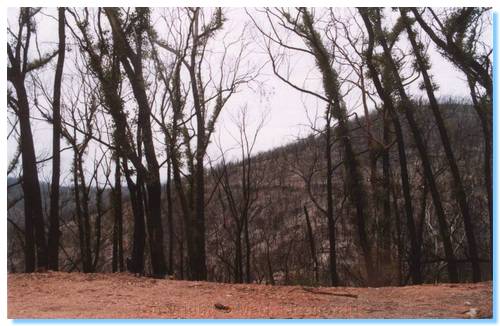
We returned back along the road into Omeo where we had our lunch. My hamburger was dropped on the floor, but they cooked me up a new one as a light rain was falling outside. The day was getting on so we made our way up the Omeo Highway towards our next rest stop at Anglers Rest. We stopped at a few points along the road to try some more unsuccessful fishing and see how the trees were coming back in an area I thought was so badly burnt that nothing could have survived. I was gladly proven wrong as the photo shows.
We arrived at the Blue Duck Inn, where we were warmly welcomed and told where the woodshed was if we wanted to keep warm tonight. Thankfully the prediction of snow didn't eventuate. I was carrying the wood back to the room when two horses galloped past; I thought they were going to crash into my car! We certainly felt like we were in an episode of McLeod's Daughters. Especially when we settled down in the pub for the best Chicken Parmagiana ever, what with everybody in Akubras and Dri-z-bones, and cattledogs walking around the tables looking for scraps! The fishing that evening and morning was, as you guessed unsuccessful.
Thursday 2nd October
We continued up the Omeo Highway through a light drizzle and stopped at Big River Bridge campground for a morning cuppa and another unsuccessful fishing attempt. There was so much water in all of the creeks and rivers we came across from the snow melt and they were all flowing high and fast. We stopped off at the cemetery in Glen Wills, which in itself had an interesting story printed on a piece of laminated paper on a post:
Between August 1894 and August 1920 97 burials took place at the Glen Wills Cemetery, on the Omeo Highway, North of Omeo and South of the Mitta Mitta township. This Cemetery is now cared for by the people of the near by Glen Valley.
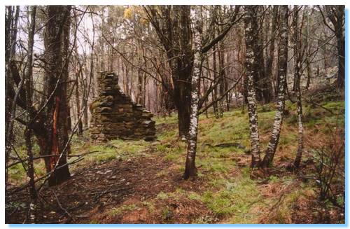
During those 26 years this Cemetery served the mining areas of Sunnyside and Glen Wills. To stand on the site of the long gone township of Sunnyside is an eerie feeling. "Sunnyside is situated on the Sunny side of nearby Mt Wills and is approximately 4000 feet above sea level. Today there is little more than blackberry bushes and a few very ancient fruit trees to mark the place where once was a thriving township. A Hotel, Stores, Catholic Church, School and Mechanics Institute and a population of around 600 people.
Sunnyside was reached by a rough bush track from Omeo known as the Knocker Track. Mail was delivered by coach and heavy goods by Bullock Wagon. Farmers from Benambra would make trips to the township with fresh meat, vegetables, butter and other produce, which was much in demand. Mr George Fitzgerald of "Shannon Vale" supplied oats to feed the horses. By 1924 the ore had become difficult to treat financially and water was also causing a problem, and not long afterwards the town was abandoned.
The Cemetery records illustrate the hardships experienced during these years - isolation, the severe weather conditions in winter, primitive housing and no doctors. Of the 97 persons buried, 40 were infants - sometime twins, sometimes a mother had died and soon after her baby. No baby formulas to feed a motherless baby, whooping cough and other illnesses would account for young children dying. Several young men were buried "by order of the Police In Charge" - I wonder what the story behind that would reveal? These truly were the Pioneers of this land.
Some years ago, due to the efforts of Mr Cecil Cooper, a sign was erected denoting Glen Wills Cemetery and a fence along the roadside. By this time only two graves were marked - one unknown and another marked by a fence in which a tree denoting the grave of Mrs Phillis Emmer Bittner, aged 43, who was buried in 1916.
In recent years (1985) a firm of bridge builders were constructing a new bridge over the Mitta Mitta river at Glen Valley. The mother of the bridge builders (of Italian descent), was visiting her sons and was amazed that there were no crosses in the Cemetery. Before leaving the area, they built a large cross on a square slab and promised that one day they would come back and erect crosses to commemorate the grave sites. This they did in the summer of 1991. As there is no plan of the actual sites of the graves, they were placed in a double row consistent with the two graves visible.
It is hoped that a dedication service of this hallowed ground will take place in the Autumn of 1992. Many people in the area have relatives buried in the Glen Wills Cemetery.
Betty Fitzgerald (Shannon Vale)
We continued from Glen Wills to Sunnyside, another old gold mining town of which little remains. We spent a considerable amount of time exploring around the old town site, finding many old relics, pieces of broken crockery, crumbling chimneys and bright daffodils from long abandoned garden beds.
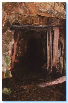
On the roadside further north from Sunnyside we came across a glorious site: an old mine shaft on the roadside with a crystal clear mountain stream gushing from within. I presume the water entered the mine further up via a ventilation shaft and made it's way down to the mine opening where it came out near the road. The recent fires had opened the forest right up and there were many old artefacts from the mining days clearly visible from the roadside which I would presume would have been previously hidden in the undergrowth. We could see tracks cut through the hillside with many pieces of rusting iron sheets, as well as trolley wheels and ore buckets spread through the forest.
We stopped at Mitta Mitta General Store, where we picked up pies and pasties for lunch, which unfortunately turned out to be cold. We headed off to Dartmouth Dam to check it out. We returned from Dartmouth via Mitta Mitta again, and continued on to our destination of Corryong. Mitta Mitta looks like a great place to spend some time, with reportedly excellent fishing, lots of mining history, and various walks including one to Bogong, Victoria's highest peak.
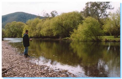
Along the way, we stopped off at a nice place on the Mitta Mitta River to try some, wait... You guessed it, unsuccessful fishing.
We passed a Sea Eagle soaring over Tatonga Inlet, and we stopped at the lookout over Old Tallangatta where the old railway and foundations of some of the houses that used to make up the town prior to its relocation still remained. Passing through a cutting of the Murray Valley Highway a hawk or kestrel swooped down and took some animal from the embankment. Further along the road I spotted an Eastern Snake-necked turtle making it's way across the road. We stopped the car, picked him up (boy do they smell) and popped on the side of the road where he was heading, down towards a small swampy area. I also spotted an Echidna digging his way into the roadside embankment.
We soon arrived in Corryong and settled into our accommodation at the
Corryong Country Inn and enjoyed a relaxing spa.
Friday 3rd October
The weather finally came good on our last day of our holidays. We made an early morning drive further up the Murray into Biggara Valley, a beautiful green valley full of cows. We sat on the banks of the river at a picnic spot there for breakfast, watching a pair of Nankeen Kestrels as they hunted for food. For reasons unknown, I tried fishing again, giving up when I finally lost my lure on a snag.
We continued towards Tintaldra where there were spectacular views back across the green valley to the Snowy Mountains in the distance. We stopped in Walwa for some lunch, they make the best Sweet Chilli Chicken Wraps and the Foccacias were pretty damn good too! We drove up to the start of the Pine Mountain walk, Pine Mountain apparently being Australia's largest monolith, 1.5 times bigger than Uluru.
From here we drove out to the Murray Valley Weir, and wasted half an hour plus, looking around Wodonga and Albury for a Shell Service Station. Giving up we drove down to Beechworth were we spent the afternoon visiting the craft galleries, picking up a very nice new vase. We also had a quick look around the cemetery, including the Chinese Burning Towers were I was swooped by a very aggressive magpie!
On the way home we stopped off in Millawa, picking up some cheeses and having dinner at the Deli there.